One Day On Boston’s Freedom Trail: Walking Itinerary
Now Go See It is reader-supported. When you buy through links on our site, we may earn an affiliate commission.
Walk Boston’s Freedom Trail end to end with timed stops, directions, and tips for every major site—from Boston Common to USS Constitution and the North End.
Boston’s Freedom Trail Itinerary: (Jump To)
Boston Freedom Trail Video Vlog Tour
Watch our Boston Freedom Trail video vlog tour for a realistic history walk—route choices, timing, and practical tips you can copy step by step. Pair the video with our Boston Freedom Trail map or book one of Boston’s historical walking tours if you want narration, then use the same approach to plan other historic walks across the city.
What to Know Before Visiting Boston
Use our Boston Freedom Trail map and pacing to move efficiently, then decide whether to go self-guided or join one of Boston’s historical walking tours for added context. If you need a base nearby, Boston hotels near the Freedom Trail keep transit simple, and we’ve noted Boston Freedom Trail parking options if you’re driving.
This guide shows how to cover all major Freedom Trail stops in one day without backtracking. Use our Freedom Trail map and timing to keep moving while still enjoying the best detours.
Book popular sites and tours in advance during summer and fall weekends. During the high season, expect lines at Old North Church, the Paul Revere House, and security at the Massachusetts State House.
The Freedom Trail is a red-brick (and sometimes painted) line that connects key Revolutionary-era and civic sites from Boston Common to Charlestown. You don’t need a tour to follow it, but ranger talks and guided walks can deepen the story if you like a narrated day.

Airline Miles and Hotel Points 101
We share tips and tricks for credit card points and miles. These tools help us save money on our trips around the world by allowing us to accumulate airline and hotel points.
Is Boston Safe?
Tourist corridors along this history walk are generally busy and well-patrolled by day, with the same common-sense rules you’d use on other historic walks in major cities. After dark, stick to main routes or rideshares and keep valuables zipped—especially around the busiest stretches near Faneuil Hall and Quincy Market.
Boston is generally safe in tourist areas, including the Freedom Trail, by day and early evening. Use common city sense—watch your bag, especially in crowds near Faneuil Hall and Quincy Market. Beacon Hill, the North End, and Charlestown see steady foot traffic and plenty of residents. Late-night trains thin out; use a rideshare if you’re wrapping up after the last tour.
You’ll share sidewalks with commuters, school groups, and tour clusters. Petty theft is uncommon but not unheard of, so zip pouches and keep your phone secure when photographing in busy spots. Cross at signals; drivers and cyclists move with purpose. After dark, stick to well-lit routes or grab a rideshare between neighborhoods.

How To Get Around Boston?
This is primarily a history walk, so plan to cover most of the route on foot and use the MBTA Red, Green, or Orange Line for quick jumps between clusters. If you’re driving, review Boston Freedom Trail parking near the route; otherwise, mix short harbor ferries and rideshares to save time when your feet or the weather demand it.
The core of this day is on foot. The Red Line, Green Line, and Orange Line all intersect near the route if you want to skip ahead. Harbor ferries from Long Wharf reach Charlestown fast when they’re running. Duck Tours and cod-speed boats are for fun, not point-to-point transit, but they’re great if you want a break with views. More on those below.
If you’re exploring further, the MBTA (the “T”) is useful. Download an offline map and the MBTA app. Buy a CharlieCard or use tap-to-pay on the T for quick hops.
If you’re looking for the easiest way to see the city with limited walking and planning, check out a Hop-on Hop-Off Tour.
Boston Freedom Trail Parking:
Boston Freedom Trail Map
Open the route before you set out—our Boston Freedom Trail map pairs turn-by-turn wayfinding with quick notes on restrooms, ferries, and T connections. Prefer narration? Overlay the path with options for historical walking tours so you can follow the red line while a guide brings the stories to life.
Combine this with the itinerary below to make the most of your time on Boston’s Freedom Trail.
Check out our other posts about things to see and do in Boston or Massachusetts!
Or visit our Destinations page to be inspired.
Freedom Trail Itinerary (Morning)
Kick off with a steady history walk from Boston Common through Beacon Hill and the State House, keeping your pace light so you can linger where it matters. If you’re parking, scan our Boston Freedom Trail parking notes first; if you’re overnighting, Boston hotels near the Freedom Trail make this morning segment effortless.
Admittedly, this plan covers more than you may want to do in just one day. The best advice is to skim over or skip the attractions that don’t interest you. You could also break the itinerary in half into a two-day Freedom Trail itinerary to make sure you have enough time to dive deeper into each stop. Click the provided website links for the most up-to-date opening hours and other information.

Boston Common
Map: Google Maps
Website: Link
Start at America’s oldest public park, established in 1634, and let the red line orient you. Swing by Parkman Bandstand, a semicircle of columns where public talks and events still happen. Climb to the Soldiers and Sailors Monument, a granite column honoring Civil War service that anchors the hill and frames views over the Common. Angle toward Tremont Street to see Brewer Fountain, a cast-iron piece with sea creatures circling the base. Don’t miss The Embrace, the interlocking arms sculpture honoring Martin Luther King Jr. and Coretta Scott King’s 1965 hug; it’s bold and sparks conversation from every angle.
This first segment takes about 30–40 minutes with photos. Restrooms are inside the Boston Common Visitor Center near the start of the trail.

Boston Public Garden and Swan Boats
Map: Google Maps
Website: Link
Cross Charles Street into the Garden, where a pond loops around the famous Swan Boats. Rides run about 15 minutes in spring through fall and can slot nicely into your morning if lines are short. The boats are human-powered and surprisingly smooth, and you’ll get water-level views of willows and footbridges. Families love it; solo travelers get the same payoff in a compact time window. If queues are long, save this for another visit and keep moving. The surrounding paths are flat and photogenic, but mind the geese.
Aim for the Commonwealth Avenue exit to line yourself up for the next photo stop.

George Washington Equestrian Statue
Map: Google Maps
Snap the classic “Welcome to Boston” shot: Washington out front, Garden behind, skyline peeking beyond. Morning light is clean here, and the pedestal gives good scale for wide frames. You’ll often see wedding shoots and graduation photos in the same spot—share the space and you’ll still get your turn. Keep this stop short so you don’t lose your morning rhythm.
If you need coffee, Newbury Street is a block away with plenty of options. From here, you’re headed into Beacon Hill.
Beacon Hill: Acorn Street
Map: Google Maps
Acorn Street is one of the city’s most photographed blocks, with brick façades, granite curbs, and cobblestones that showcase Federal-era design. Expect a crowd composing their best Instagram moments. Be careful on the stones—they can be slick after rain. The homes are lived in, so be respectful with noise and doorsteps. This stop is about getting the feel of Beacon Hill’s scale and materials up close. If you’re short on time, one lap and a few photos will do.
Keep your eyes on the red line markers as you exit toward Mount Vernon Street.

Nichols House Museum
Map: Google Maps
Website: Link
Free Admission for NARM Members
If tour times align, step into this 1804 townhouse to see a lived-in, upper-crust home rather than a pristine showpiece. Inside are period rooms, everyday objects, and a sense of how domestic life worked as Beacon Hill was built out. Tours are guided, so check the day’s schedule before committing; it’s a quick, focused visit. You’ll pick up details about furniture, entertaining, and the people who kept homes running. It’s a nice counterpoint to the more overtly political sites you’ll see later. If timing doesn’t match, keep moving and don’t sweat it—this is an optional add.
Head uphill toward the gold dome next.

Massachusetts State House
Map: Google Maps
Website: Link
Tour Info: Link
Designed by Charles Bulfinch and topped with an unmissable gold dome, the State House caps the hill with confidence. Weekday tours are typically free when the legislature isn’t in session; security screening is standard. Inside, you’ll see historic chambers, murals, and displays that connect state government to the city’s longer story. Outside, statues on the lawn make a quick lap worthwhile, and the view over the Common ties your morning together. Expect 20–40 minutes, depending on whether you go inside. If you’re budgeting time, a fast exterior visit keeps you on schedule.
From here, angle downtown along the red bricks.

Old State House and Boston Massacre Site
Map: Google Maps
Website: Link
Tickets: Viator
Out front you’ll spot the lion and unicorn where royal symbols once declared British authority; it’s a striking visual right in the modern core. Inside, the museum is tight and well-curated, guiding you through the road to revolution with artifacts and clear storytelling. The balcony is famous as the spot where the Declaration of Independence was read to Bostonians on July 18, 1776. Just steps away is the Boston Massacre site—a cobblestone marker that rewards a brief, quiet minute. Picture the crowd, the tension, and how fast things spiraled on March 5, 1770. Combined tickets are available for this museum and Old South Meeting House, which can save both time and money; check Viator or the sites directly for bundles. Expect 45–60 minutes here if you linger.
Walk two blocks via Washington Street to The Old South Meeting House.

We’re on YouTube!
The same great content without all the pesky reading!
Boston Freedom Trail Itinerary (Afternoon)
Continue through Faneuil Hall, the North End, and Charlestown on one of the most iconic historic walks in the U.S., with flexible time windows for each stop. Save a little buffer for the USS Constitution and Bunker Hill, and consider a short harbor hop or one of Boston’s historical walking tours if your feet need a break.

Old South Meeting House
Map: Google Maps
Website: Link
Tickets: Viator
On December 16, 1773, thousands packed this building, argued for hours, and left with a plan that became the Boston Tea Party. Interiors are straightforward: box pews, side galleries, and exhibits that explain how the space functioned. The focus is on debate, decision-making, and the chain of events that followed. You can do a solid visit in 25–35 minutes if you keep your pace. If you’re collecting guided commentary, ranger and docent talks here are great when they’re running.
Exit back to the bricks and aim for the cemetery ahead.

Granary Burying Ground
Map: Google Maps
Website: Link
Keep it respectful as you pass slate stones that tilt from centuries of frost and heat. You’re here for names that anchor every textbook: John Hancock with the unmistakable signature, Paul Revere who did far more than one midnight ride, Samuel Adams the organizer, and victims of the Boston Massacre. Paths are narrow, so step aside for photos and let groups pass. Spend 10–15 minutes locating the markers and reading the interpretive signs. It’s compact but weighty. There are benches near the entrance if you need a breather.
When you’re ready, follow the bricks toward lunch.

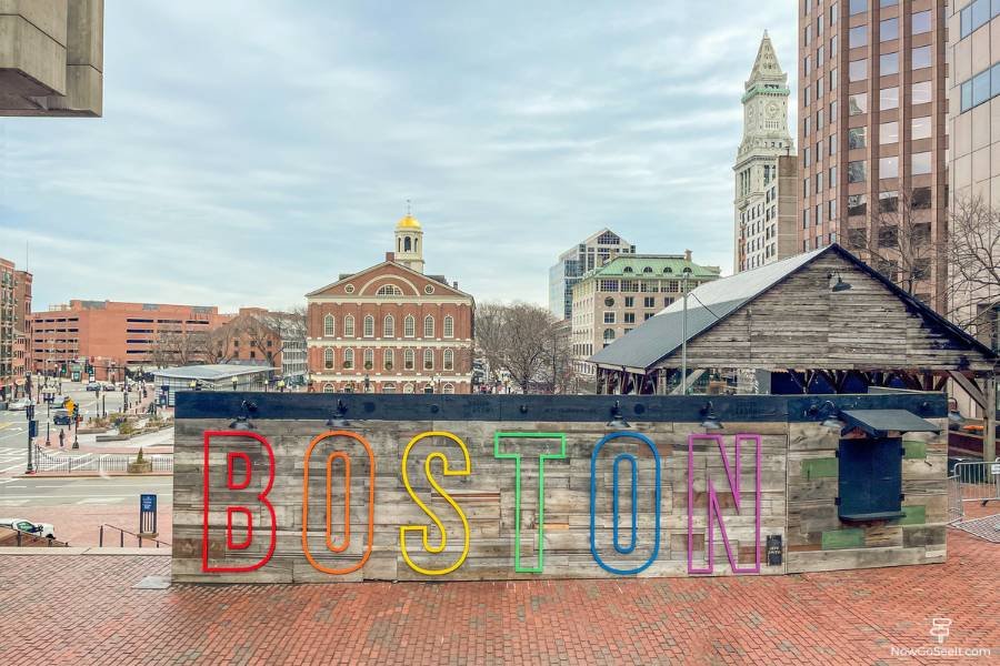
Faneuil Hall and Quincy Market
Map: Google Maps
Website: Link
Faneuil Hall remains a hall for public talk, with short, smart ranger programs upstairs when they’re running. The exterior is classic brick-and-granite with a weathervane on top and makes for a quick, satisfying stop. Behind it, Quincy Market is your concentrated lineup of snacks and New England comfort dishes inside a long granite-and-brick arcade with a domed rotunda. Expect lines at peak lunch; pick a counter and commit—lobster rolls, clam chowder, and slices of Boston cream pie are the headliners. It’s a little overpriced but delivers the flavors you came for.
If you want a sit-down meal instead of counter service, don’t wander too long—there’s a historic option nearby.

Union Oyster House
Map: Google Maps
Website: Link
Two minutes from Quincy Market, this is the oldest continuously operating restaurant in the country, serving since 1826. The interior is wood-paneled and close, with a raw bar that keeps the shuckers busy. Chowder, oysters, and baked beans land fast and hit the New England comfort targets. Ask for a quick table if you’re on the clock; servers understand that many guests are following the Trail. Prices reflect the history and location, but the experience is satisfying if you want a proper seat. If you’re skipping lunch, pop in for a cup of chowder and move on.
Cross the busy street behind Quincy Market to land at the Historic North End.

Long Wharf and the Waterfront
Map: Google Maps
Codzilla Tickets: Viator
Duck Tours: Viator
Walk to Long Wharf for harbor air and options: commuter ferries, island shuttles, and sightseeing cruises all depart here. If your feet want a reset, a short ferry ride is the most Boston way to do it and gives you skyline views without committing hours. Codzilla, the bright red high-speed ride, tears out of here in summer; it’s loud, splashy, and fun if you want a jolt. Duck Tours splash down nearby and then roam on land—an amphibious loop that doubles as a narrated city highlight reel. Both Duck Tours and Codzilla can be pre-booked through GetYourGuide or Viator in peak months. Keep your eye on time; the North End and Charlestown still await.
The plaza here also anchors the next major family stop.

New England Aquarium
Map: Google Maps
Website: Link
Tickets: Viator
The Aquarium sits right on the waterfront with indoor exhibits and an outdoor harbor seal area that you can view without a ticket. Inside, a central ocean tank spirals upward with rays, sharks, and reef life; it’s efficient to visit if you move with purpose. Families can spend hours here, but Freedom Trail travelers usually budget 45–60 minutes. If lines are long, enjoy the seals outside and keep going. The benches along the water are useful for a quick sit and shoe adjustment. Snacks are easy to grab nearby if you need a sugar bump. Next up: the North End.
Walk about 10 minutes toward the North End.

North End Overview and Hanover Street
Map: Google Maps
Hanover Street runs through the Italian heart of the North End, lined with bakeries, butcher shops, and red-sauce institutions. Weekends bring street closures for summer feast days and a neighborhood crowd that knows where they’re headed. If you’re light on time, focus on a pastry stop and one landmark church visit. The area is compact but dense, so expect to move slowly. This is also a good spot to refill water before you climb in Charlestown. Save a little room for cannoli.

Modern Pastry
Map: Google Maps
Website: Link
Glass cases here go long with cannoli, biscotti, and a rotation of cookies that are hard to choose between. The line moves, but the selection looks better the longer you stare at it—pick quickly. Filling choices vary; classic ricotta with chocolate chips is always a win. Staff are efficient and appreciate a clear order. If you’re traveling solo, a single cannolo and a coffee are perfect fuel for the next hour. Boxed cookies travel well if you’re meeting friends later. Don’t worry about comparing yet; Mike’s is just up the street.

Mike’s Pastry
Map: Google Maps
Website: Link
Mike’s sends folks out with string-tied boxes; opinions run hot about which shop is best, and we’re not picking sides. The case features filled-to-order cannoli in flavors that range from traditional to sweet-tooth specials. Lines can wrap around the block but tend to move faster than they look. If you just did Modern, consider a different treat here to spread the love. Carry napkins—cannoli can be messy on the go.
When you’re done, it’s time for the trio that defines this neighborhood for many visitors.

Paul Revere House, Paul Revere Statue, and Old North Church
Map: Google Maps
Website: Link
Tickets: Viator
The Paul Revere House is small, wooden, and old even by Boston standards—circa 1680—and gives a direct, physical link to the person behind the poem. Around the corner, the Paul Revere Statue in the Paul Revere Mall (locals call it the Prado) frames a clean shot toward the Old North steeple. Old North Church stands where lanterns signaled “one if by land, two if by sea” on April 18, 1775, and the interior—with box pews and a gallery level—lands the story simply. Ticket lines here can be long, but even an exterior visit through the courtyard gives context if you’re pressed. Expect 45–60 minutes if you go inside both sites.
When you’re set, it’s time to cross the water.

William Felton “Bill” Russell Bridge to Charlestown
Map: Google Maps
Website: Link
Cross the span locals use to link the North End and West End to Charlestown; water views and the skyline make this a pleasant reset. The grade is mild and the sidewalks are wide enough to keep your pace. Watch bikes when entering and exiting ramps. This crossing lines you up for a straight approach to the hill. If your legs are fading, rideshare to Monument Square is an easy save. Otherwise, keep a steady pace and enjoy the view back toward downtown.
Next stop is the obelisk you’ve been spotting all afternoon.

Bunker Hill Monument
Map: Google Maps
Website: Link
The 221-foot obelisk marks the June 17, 1775 battle where colonial forces lost the hill but proved they could stand up to the British army in open combat. If the tower is open and you’re ambitious, climb 294 steps—no elevator, just your legs and some pride. The base area and Monument Square are worth a slow lap even if you don’t go up. Exhibits explain the battle’s quick escalation and why it mattered to strategy on both sides. Plan 20–40 minutes depending on the climb. Bathrooms and water are limited here; plan ahead.
Your final stops are down to the waterfront once more.

Charlestown Navy Yard and USS Constitution
Map: Google Maps
Website: Link
The Navy Yard tied Boston to shipbuilding and maintenance for more than a century, and it’s a strong capstone to the Trail. USS Constitution—“Old Ironsides”—launched in 1797 and remains in commission; tours are free when the ship is open, and sailors serve as guides, which is as good as it sounds. Reality note: it’s closed on Monday, which is exactly when I showed up, so I couldn’t go aboard. If that happens to you, the USS Constitution Museum next door is typically open daily with suggested admission and does a tidy job filling in the story. The dry docks, brick sheds, and waterfront paths are atmospheric even after closing hours. If you’re short on time, prioritize the ship over the museum when it’s open.
When you’re done, the MBTA ferry back to Long Wharf is a scenic way to end.


If You Have More Time in Boston
Add a second day for museum time and harbor views—pair this route with the Black Heritage Trail, the Boston Tea Party Ships & Museum, and a ferry to the Boston Harbor Islands when boats are running. For a deeper dive, branch into more historic walks or book one of Boston’s historical walking tours, using our Boston Freedom Trail map to link neighborhoods without backtracking.
Add the Boston Tea Party Ships & Museum for an interactive take on the 1773 meeting you learned about at Old South. Take a harbor ferry to Georges Island for Fort Warren when boats are running. The Black Heritage Trail on Beacon Hill pairs well with what you saw on the Common and at the State House. The Museum of Fine Arts and the Isabella Stewart Gardner Museum offer world-class collections if you want an art-heavy detour on a different day. For families, the USS Cassin Young, a WWII destroyer docked near the Constitution, is an excellent bonus when open.
Small adds and booking notes: Combined tickets for the Old State House and Old South Meeting House are often the best value; check direct or via Viator. Duck Tours and Codzilla are peak-season favorites; GetYourGuide and Viator both list timed departures that sell out on weekends. A lightweight power bank, compact umbrella, and refillable bottle make the day smoother—Amazon has solid, inexpensive options. If you’re visiting during summer, prebook Old North Church and the Paul Revere House to lock timing.
If this guide helped you plan the day, a quick subscribe on YouTube truly helps us keep building detailed city guides.

Things To Do On The Boston Freedom Trail:
Boston Common
Boston Public Garden and Swan Boats
George Washington Equestrian Statue
Beacon Hill: Acorn Street
Nichols House Museum
Massachusetts State House
Old State House
Boston Massacre Site
Old South Meeting House
Granary Burying Ground
Faneuil Hall
Quincy Market
Union Oyster House
Long Wharf
New England Aquarium
Modern Pastry
Mike’s Pastry
Paul Revere House
Paul Revere Statue and the Prado
Old North Church
William Felton “Bill” Russell Bridge
Bunker Hill Monument
Charlestown Navy Yard
USS Constitution
USS Constitution Museum