Make Your Own Travel Map: Travel Planning with Google Maps
Now Go See It is reader-supported. When you buy through links on our site, we may earn an affiliate commission.
A quick and easy way to use Google Maps to streamline your travel planning.
Travel Planning with Google Maps: (Jump To)
It sounds pretty obvious to tell you that I use Google Maps to plan my international and domestic travel. Everyone knows it’s the preferred tool to get from here to there or to find the closest coffee shop.
My pre-trip planning is pretty in-depth. I like to have everything planned in advance. Nothing scares me more than missing something spectacular in a city because I didn’t research in advance.
I think it is important to allow for some spontaneity in travel too. As much as I plan, I can’t plan for bad weather, canceled or missed trains and planes, or the unexpected travel surprise that needs to be chased. Having a well-designed plan makes it easy to be able to change course and re-correct.
Make Sure to Download Google Maps
Before you do anything you’re going to need a Google account. If for some crazy reason, you don’t have one, it’s free to sign up and use. You’ll need to download the Google Maps app on your phone. Make sure to sign in on your phone and on your computer browser.
Also, while you’re at home and connected to your home wi-fi, you should download offline maps of your destination. This way you’ll have them saved to your phone to either access in airplane mode or to save you the expensive international data rates. This function is available by clicking the icon in the top right corner, and then selecting offline maps. From there you tap Select Your Own Map, move the map to your destination, and tap Download.
Using the ‘Save’ Function to Organize
My favorite Google Maps tool is the Save function. When the results appear from a search the option to Save appears below the description. If you click on the Save circle you’re presented with three preset choices: Favorites, Want to Go, and Starred Places. It also gives you the option to create a new list. I use these three preset options almost exclusively to plan and prepare.
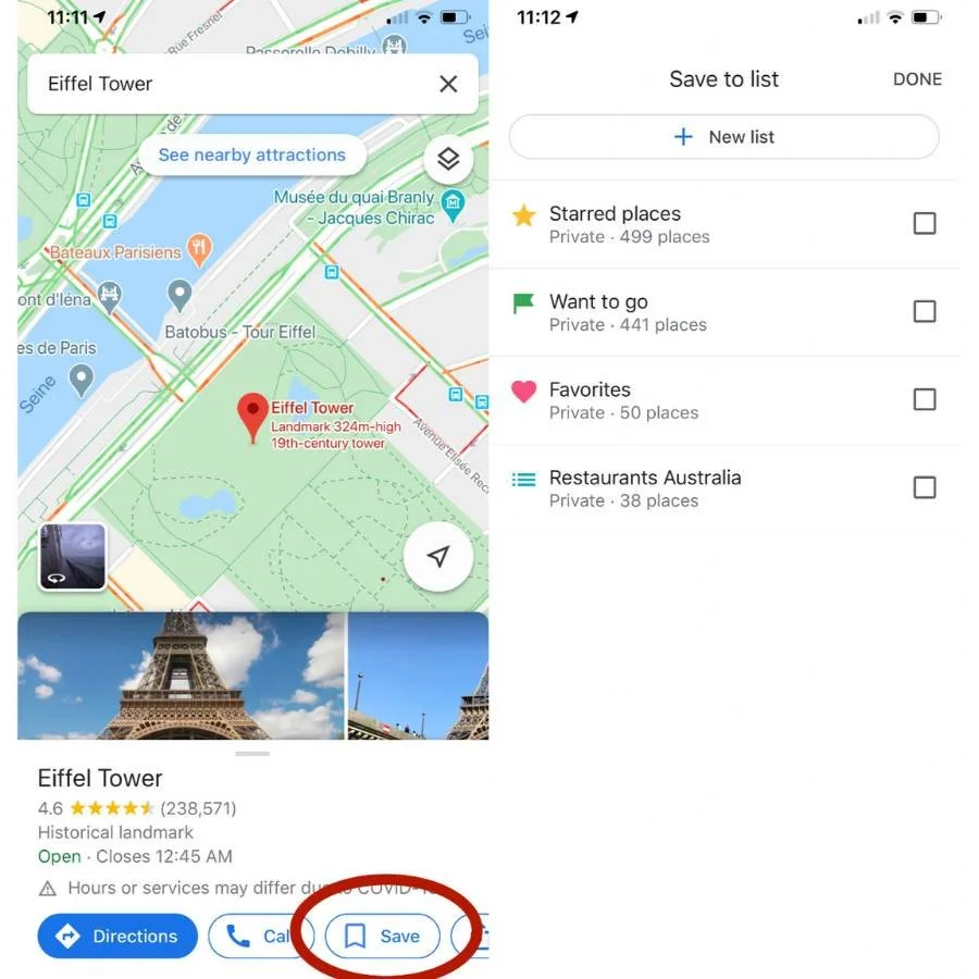
When you save items to these categories they go into a list that can be accessed in the Your Places section of the menu (accessed by clicking the Saved tab on the App or the three lines in the top left on a browser). More importantly, the place becomes visually saved on the map as one of three icons.
A heart icon shows places listed as Favorites. I use the heart to label all the places on the trip that are set in stone. Places I know I will be visiting as vital places during the trip. These are places like airports, central train stations, cruise ship terminals, and our hotel for the night. When I see a heart on the map, I know it’s important.
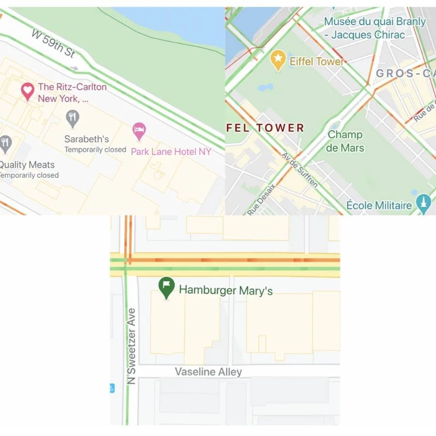
A star icon is for Starred Places. This is for tourist destinations, shopping stops, or museums. Essentially any place you want to go while in a city. Doing it this way is amazingly handy. When I’m reading a travel guide and it mentions a place that sounds interesting, I reach for my phone, pull it up, and save it with a star. If I mention my upcoming trip and someone gives me a travel tip, I can pull my phone out and quickly Star the destination to my map.
Finally, the Want to Go icon, a green flag, is reserved for food. Similar to Starred Places, any time I read about a great place to eat, or someone recommends an off-the-beaten-path cafe I can grab my phone and flag it as Want To Go.
Pre-Trip Planning
As my pre-trip planning happens, I start to update my Google Maps. When I book my flights I heart my airports. When I book my hotel, It gets a heart. When Lonely Planet highlights a must-see destination, it gets a star. When a YouTuber vlogs a cafe, it gets a flag. All planning sources get funneled into my map. Before I know it. I have a map full of hearts, stars, and flags.
Using your Hearts, Stars, and Flags
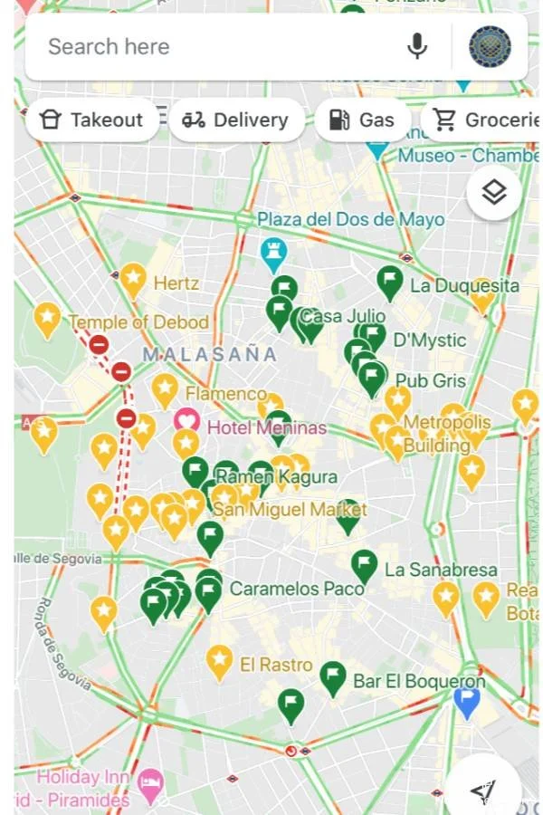
Now I have a visual way to decide where to go when. If I decide that my first morning in Paris with begin at the Eiffel Tower, I can pull it up and instantly see what's nearby. Looks like Rick Steves recommends shopping on Rue Cler Market Street, is a ten-minute walk away. The Rodin Museum is a short walk from there, and I can walk by the landmark golden Les Invalides dome on the way. Suddenly I have a morning plan.
Tuesday:
Subway to Gare Champ de Mars Tour Eiffel station, See Eiffel Tower
Walk 10 minutes to shop on Rue Cler Market Street
Walk 14 minutes to Rodin Museum via Rue de Grenelle passing Les Invalides landmark
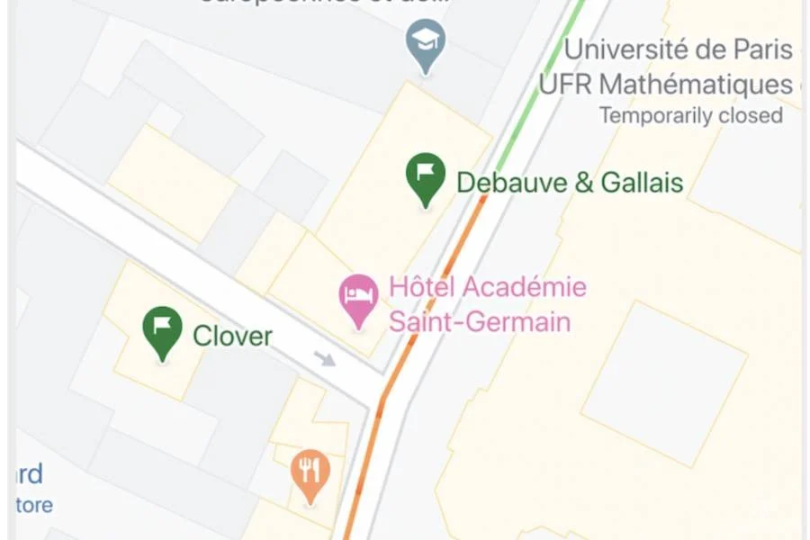
Quickly and easily my first morning in Paris is planned. Now I know about where I will be when lunchtime hits. So I type in Rodin Museum and look for some green flags. Lonely Planet recommends Clover for lunch and it just happens to be right next to Iconic chocolatier Debauve & Gallais. Lunch and dessert are planned! If the chocolate shop wasn’t flagged I might not have even noticed it was next door.
This is the other great part about the flags and stars. As I plan my routes I notice what I'm passing on my routes. I would almost never go out of my way to visit a recommended chocolate shop, but if I happen to be walking by, or know I can take a slightly different route to walk by, I’d be crazy not to stop in.
Likewise, I know for sure I want to see the Eiffel Tower, the Louvre, and the Notre Dame while in Paris. They’re my “must-sees.” The quaint shopping street of Rue Cler or the Rodin Museum are places that I could leave the city without visiting, but visually seeing their proximity to my prime morning destination makes it easy to fill out my day and minimize my time traveling around the city.
Be Flexible
Now, just because I put Clover into my plan for lunch doesn’t mean we won’t walk by something that lures us in when we’re on the streets of Paris smelling the smells and seeing into the windows. Our plan is merely a guide to avoid ever having the “what do you want to do today?” conversation over a free hotel breakfast.

This system comes in very handy when your plans have to change. If hunger strikes earlier than expected, you can pull up your Google Maps app and easily see what’s flagged close by. If you’re about to walk into a museum only to discover it’s unexpectedly closed, you can pull up your map and see a starred location nearby that could be an alternative for the time. If rain hits and your day enjoying the park is canceled, a starred museum can fill in.
I almost never erase my Saved locations. It becomes a great way to remember the trip and to share what I’ve found on my travels. Sometimes when I’m in a great cafe that I loved, I pull out my phone and give it a green flag so I can share it with others too.


![Packing For Summer in Europe [Downloadable Checklist]](https://images.squarespace-cdn.com/content/v1/5ee7e52abb85ae589d30a8db/1713885428179-0JC5XALNFGVGD7ER4WWT/Packing+For+Europe.jpg)